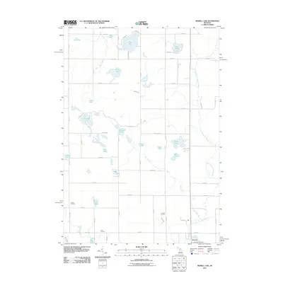
2011 Map of Merrill Lake
USGS Topo · Published 2011About this map
The village of Barryton serves as the focal point for this 2011 survey, situated along the North Branch Chippewa River where its waters meet the Roundy Branch. This pocket of central Michigan is defined by a dense network of glacial lakes and small drainage systems, including the interconnected Rattail Lakes and Browns Lake. The landscape is organized by a rigid grid of rural roads such as 20 Mile Rd and Meceola Rd, which connect remote lakefront settlements and family farmsteads. For those studying local history, the map provides precise locations for several community burial grounds, including Sparks Cemetery, Eaton Cemetery, and Brown Cemetery. These sites, along with the Barryton Post Office, represent the institutional anchors of the township in the early 21st century. The map also traces various smaller tributaries like Thorn Creek and Rattail Creek as they weave through the surrounding wetlands and timbered sections.
Find a feature on this map
46 named features on this map. Tap any name to fly to it.
Don’t see what you’re looking for? This feature index may not catch every label — zoom into the map to look around manually.
Map Details
Editions of this 2011 Merrill Lake Map
This is the sole edition of this map. No revisions or reprints were ever made.
Other maps of this area

1954 · Midland
USGS Topo · 1:250,000

1958 · Midland
USGS Topo · 1:250,000

1958 · Big Rapids
USGS Topo · 1:62,500

1959 · Midland
USGS Topo · 1:250,000

1959 · Lake
USGS Topo · 1:62,500

1959 · Evart
USGS Topo · 1:62,500

1964 · Mecosta NW
USGS Topo · 1:24,000

1964 · Sherman City
USGS Topo · 1:24,000

1966 · Midland
USGS Topo · 1:250,000
1976 · Big Rapids NE
USGS Topo · 1:24,000