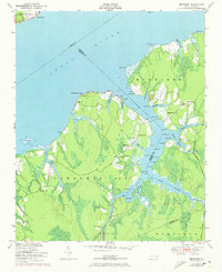
1951 Map of Merrimon
USGS Topo · Published 1973About this map
Merrimon and the surrounding coastal wetlands of Merrimon Township No 5 are defined by the convergence of the Neuse River and the Adams Creek Intracoastal Waterway. This survey illustrates a landscape deeply connected to the water, where settlements like Great Neck are separated by a complex network of tidal creeks including Dumpling Cr, Courts Cr, and Kellum Cr. The presence of several community anchors, such as Merrimon Ch, Reels Chapel, and Antioch Ch, alongside the Adams Creek Sch, highlights the social fabric of these rural peninsula communities during the mid-20th century.
Find a feature on this map
41 named features on this map. Tap any name to fly to it.
Don’t see what you’re looking for? This feature index may not catch every label — zoom into the map to look around manually.
Map Details
Editions of this 1951 Merrimon Map
2 editions found
Other maps of this area

1948 · Oriental
USGS Topo · 1:24,000

1949 · Merrimon
USGS Topo · 1:24,000

1949 · Newport
USGS Topo · 1:24,000

1949 · Williston
USGS Topo · 1:24,000

1949 · South River
USGS Topo · 1:24,000

1949 · Cherry Point
USGS Topo · 1:24,000

1949 · Core Creek
USGS Topo · 1:24,000

1950 · South River
USGS Topo · 1:24,000

1950 · Arapahoe
USGS Topo · 1:24,000

1951 · Williston
USGS Topo · 1:24,000