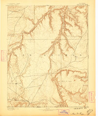
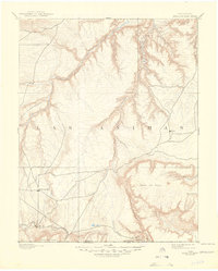
1893 Map of Mesa De Maya
USGS Topo · Published 1896About this map
Troy and Indianapolis appear as small, isolated outposts in this 1890s survey of the high plains and canyonlands of southeastern Las Animas County. The landscape is dominated by the massive Mesa De Maya and a complex system of erosional features, including the deeply incised Chaquaqua Canyon and Potrero Canyon. These landforms dictate the early travel routes and settlement patterns, with roads following the drainage of Tinchera Creek and Chaquaqua Creek.
Find a feature on this map
24 named features on this map. Tap any name to fly to it.
Don’t see what you’re looking for? This feature index may not catch every label — zoom into the map to look around manually.
Map Details
Editions of this 1893 Mesa De Maya Map
6 editions found
Other maps of this area

1891 · Higbee
USGS Topo · 1:125,000

1891 · Timpas
USGS Topo · 1:125,000

1891 · Apishapa
USGS Topo · 1:125,000

1891 · Mesa De Maya
USGS Topo · 1:125,000

1892 · Elmoro
USGS Topo · 1:125,000

1892 · Mt Carrizo
USGS Topo · 1:125,000

1893 · Higbee
USGS Topo · 1:125,000

1893 · Apishapa
USGS Topo · 1:125,000

1893 · Elmoro
USGS Topo · 1:125,000

1893 · Mesa de Maya
USGS Topo · 1:125,000