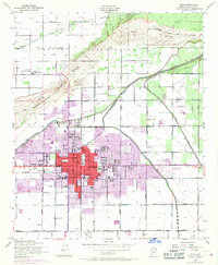
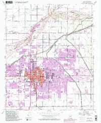
1952 Map of Mesa
USGS Topo · Published 1968About this map
The Salt River Indian Reservation dominates the northern half of this landscape, where the Salt River channel winds through a network of early roads and irrigation works like the Aqueduct and Tempe Canal. In the early 1950s, the urban core of Mesa is centered on Main and Mesa Drive, featuring local landmarks like the LDS Temple, City Hall, and Taylor Field. Educational and community centers such as Irving Sch, Webster Sch, and Alma Sch anchor the residential neighborhoods.
Find a feature on this map
62 named features on this map. Tap any name to fly to it.
Don’t see what you’re looking for? This feature index may not catch every label — zoom into the map to look around manually.
Map Details
Editions of this 1952 Mesa Map
5 editions found
Other maps of this area

1904 · Camelback
USGS Topo · 1:62,500

1904 · Desert Well
USGS Topo · 1:62,500

1904 · Ft. McDowell
USGS Topo · 1:62,500

1906 · Camelsback
USGS Topo · 1:62,500

1906 · Ft. McDowell
USGS Topo · 1:62,500

1906 · Desert Well
USGS Topo · 1:62,500

1913 · Mesa
USGS Topo · 1:62,500

1915 · Mesa
USGS Topo · 1:62,500

1930 · Cave Creek
USGS Topo · 1:125,000

1939 · Cave Creek
USGS Topo · 1:125,000