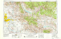
1954 Map of Mesa
USGS Topo · Published 1979About this map
Phoenix and the expanding East Valley communities of Mesa, Tempe, and Scottsdale define the western portion of this mid-century survey, showing the region before the massive post-war urban sprawl fully merged these desert cities. The map tracks the vital water management systems of the Salt River and Gila River, featuring the massive Theodore Roosevelt Lake and San Carlos Reservoir. To the east, the topography shifts into the formidable Superstition Mountains and the Tonto National Forest. Cultural and military footprints are prominent, from the ancient Casa Grande Ruins NM to the active runways of Williams AF Base. Transportation networks like the Southern Pacific railroad and the Magma Arizona line connect the copper mining districts of Miami and Globe to the agricultural and metropolitan centers, illustrating the industrial and residential transition of the era.
Find a feature on this map
110 named features on this map. Tap any name to fly to it.
Don’t see what you’re looking for? This feature index may not catch every label — zoom into the map to look around manually.
Map Details
Editions of this 1954 Mesa Map
4 editions found

Other maps of this area

1886 · St Johns
USGS Topo · 1:250,000

1886 · Holbrook
USGS Topo · 1:250,000

1887 · Verde
USGS Topo · 1:250,000

1887 · Prescott
USGS Topo · 1:250,000

1892 · Verde
USGS Topo · 1:250,000

1892 · St Johns
USGS Topo · 1:250,000

1892 · Prescott
USGS Topo · 1:250,000

1893 · Holbrook
USGS Topo · 1:250,000

1900 · Florence
USGS Topo · 1:125,000

1901 · Globe
USGS Topo · 1:62,500