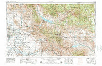
1954 Map of Mesa
USGS Topo · Published 1979About this map
The Superstition Mountains and the vast reaches of the Tonto National Forest dominate this regional landscape, documenting the Arizona desert just as the Phoenix metropolitan area began its significant postwar expansion. While Phoenix, Tempe, and Mesa show a developing grid of streets and irrigation, the areas to the east remain defined by rugged terrain and industrial extraction. Mining operations at Magma and Inspiration near Globe highlight the copper-driven economy of the era. Significant water management is evident through the massive Theodore Roosevelt Lake and San Carlos Reservoir, which supported both agriculture and the growing desert settlements. Transport infrastructure, including the Southern Pacific railroad and the network of the Gila River and Salt River, provided the lifelines for these isolated communities before the full modernization of the state's highway system.
Find a feature on this map
45 named features on this map. Tap any name to fly to it.
Don’t see what you’re looking for? This feature index may not catch every label — zoom into the map to look around manually.
Map Details
Editions of this 1954 Mesa Map
4 editions found

Other maps of this area

1886 · St Johns
USGS Topo · 1:250,000

1886 · Holbrook
USGS Topo · 1:250,000

1887 · Verde
USGS Topo · 1:250,000

1887 · Prescott
USGS Topo · 1:250,000

1892 · Verde
USGS Topo · 1:250,000

1892 · St Johns
USGS Topo · 1:250,000

1892 · Prescott
USGS Topo · 1:250,000

1893 · Holbrook
USGS Topo · 1:250,000

1900 · Florence
USGS Topo · 1:125,000

1901 · Globe
USGS Topo · 1:62,500