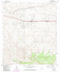
1973 Map of Mescal
USGS Topo · Published 1984About this map
Mescal and its high-desert surroundings are defined by the critical junction of the Southern Pacific railroad and the early interstate highway system. This 1970s landscape shows the integration of ranching and modern infrastructure, where established operations like the Double X Ranch and Jay Six Ranch share the terrain with a network of pipelines and communications towers. The settlement of Paso and the Williams Ranch are situated along the margins of the Coronado National Forest, highlighting the area's transition from open range to protected federal lands. The topography is deeply incised by watercourses such as Mescal Wash and Anderson Canyon, which drain the northern slopes of the Whetstone Mountains. Numerous water sources, including Wakefield Spring and Little Nogales Spring, illustrate the importance of reliable water in this arid environment for both livestock and the historic rail corridor that follows the natural grades toward the San Pedro Valley.
Find a feature on this map
33 named features on this map. Tap any name to fly to it.
Don’t see what you’re looking for? This feature index may not catch every label — zoom into the map to look around manually.
Map Details
Editions of this 1973 Mescal Map
2 editions found
Other maps of this area

1904 · Patagonia
USGS Topo · 1:125,000

1904 · Tucson
USGS Topo · 1:125,000

1905 · Patagonia
USGS Topo · 1:125,000

1905 · Tucson
USGS Topo · 1:125,000

1915 · Benson
USGS Topo · 1:125,000

1926 · Whetstone
USGS Topo · 1:62,500

1943 · Benson
USGS Topo · 1:125,000

1945 · Happy Valley
USGS Topo · 1:62,500

1956 · Nogales
USGS Topo · 1:250,000

1956 · Tucson
USGS Topo · 1:250,000