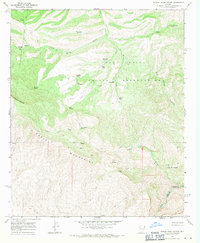
1968 Map of Mescal Warm Spring
USGS Topo · Published 1971About this map
The San Carlos Indian Reservation dominates the northern half of this landscape, where the rugged descent toward the Gila River is marked by a complex network of canyons and water sources. Ranching life in the late 1960s is evident through features like Van Winkle Ranch, several corrals, and various water improvements including Wagon Wheel Well and Mescal Tank. The southern portion is defined by the high peaks of the Mescal Mountains and El Capitan Mountain, where a single Prospect suggests limited mining exploration in the area. Remote Jeep Trails provide the only access through this arid environment, connecting isolated points like Wild Horse Spring and Red Whiskers Spring before reaching the geothermal waters at Mescal Warm Spring near the river's edge.
Find a feature on this map
32 named features on this map. Tap any name to fly to it.
Don’t see what you’re looking for? This feature index may not catch every label — zoom into the map to look around manually.
Map Details
Editions of this 1968 Mescal Warm Spring Map
2 editions found
Other maps of this area

1901 · Globe
USGS Topo · 1:62,500

1902 · Globe
USGS Topo · 1:62,500

1910 · Ray
USGS Topo · 1:62,500

1915 · Christmas
USGS Topo · 1:62,500

1917 · Christmas
USGS Topo · 1:62,500

1954 · Mesa
USGS Topo · 1:250,000

1957 · Mesa
USGS Topo · 1:250,000

1958 · Mesa
USGS Topo · 1:250,000

1960 · Mesa
USGS Topo · 1:250,000

1964 · Mesa
USGS Topo · 1:250,000