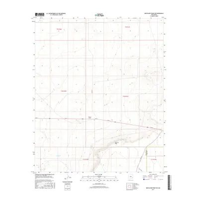
2017 Map of Mescalero Point NE
USGS Topo · Published 2017About this map
Mescalero Ridge dominates the southern landscape of this Lea County quadrangle, where the high plains of the Llano Estacado meet the dramatic escarpment. This 2017 survey documents a sparsely populated ranching and energy corridor along the border of Chaves and Lea counties. Industrial infrastructure is visible through names like Tower Rd and Twin Tower, while the historical reliance on water management in this arid environment is evidenced by Pecan Tank and Cottonwood Tank. The township and range lines of the Public Land Survey System, including t10s r31e and t11s r31e, provide a rigid grid over the natural cuts of Polecat Canyon. Roads such as Mathers Rd and 2nd St cut across the landscape, serving as the primary arteries through this high-desert terrain near the Caprock.
Find a feature on this map
16 named features on this map. Tap any name to fly to it.
Don’t see what you’re looking for? This feature index may not catch every label — zoom into the map to look around manually.
Map Details
Editions of this 2017 Mescalero Point NE Map
This is the sole edition of this map. No revisions or reprints were ever made.
Other maps of this area

1954 · Brownfield
USGS Topo · 1:250,000

1958 · Brownfield
USGS Topo · 1:250,000

1962 · Brownfield
USGS Topo · 1:250,000

1973 · Culp Ranch
USGS Topo · 1:24,000

1973 · Mescalero Point
USGS Topo · 1:24,000

1973 · Soldier Hill
USGS Topo · 1:24,000

1973 · Caprock
USGS Topo · 1:24,000
1973 · Oasis
USGS Topo · 1:24,000

1973 · Mescalero Point NE
USGS Topo · 1:24,000
1978 · Presler Lake
USGS Topo · 1:24,000