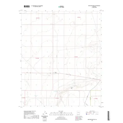
2020 Map of Mescalero Point NE
USGS Topo · Published 2020About this map
Mescalero Ridge dominates the southern reaches of this landscape on the border of Chaves and Lea Counties. The terrain is defined by its arid drainage patterns and isolated water sources, most notably the seasonal flow at Polecat Canyon and localized catchments such as Pecan Tank and Cottonwood Tank. These features reflect the historic reliance on specific water points for ranching and movement through the high desert. A sparse but intentional road network, including Mathers Rd and Tower Rd, cuts through the Public Land Survey System grids, connecting remote points across the desert floor. The inclusion of names like Twin Tower suggests landmarks used for navigation or communications in an otherwise open and expansive area of southeastern New Mexico.
Find a feature on this map
17 named features on this map. Tap any name to fly to it.
Don’t see what you’re looking for? This feature index may not catch every label — zoom into the map to look around manually.
Map Details
Editions of this 2020 Mescalero Point NE Map
This is the sole edition of this map. No revisions or reprints were ever made.
Other maps of this area

1954 · Brownfield
USGS Topo · 1:250,000

1958 · Brownfield
USGS Topo · 1:250,000

1962 · Brownfield
USGS Topo · 1:250,000

1973 · Culp Ranch
USGS Topo · 1:24,000

1973 · Mescalero Point
USGS Topo · 1:24,000

1973 · Soldier Hill
USGS Topo · 1:24,000

1973 · Caprock
USGS Topo · 1:24,000
1973 · Oasis
USGS Topo · 1:24,000

1973 · Mescalero Point NE
USGS Topo · 1:24,000
1978 · Presler Lake
USGS Topo · 1:24,000