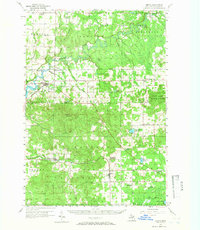
1956 Map of Mesick
USGS Topo · Published 1966About this map
The Manistee River winds through the heart of this mid-1950s Wexford County landscape, passing under Harvey Bridge and Baxter Bridge as it flows toward the Hodenpyl Dam Pond. This era shows a rural Michigan interior defined by small timber and rail settlements, many of which were already seeing shifts in their landscape. The Ann Arbor RR corridor serves as a primary axis for towns like Mesick, Harrietta, and Boon, while the surrounding forest land is managed under the Fife Lake State Forest and Manistee National Forest.
Find a feature on this map
68 named features on this map. Tap any name to fly to it.
Don’t see what you’re looking for? This feature index may not catch every label — zoom into the map to look around manually.
Map Details
Editions of this 1956 Mesick Map
3 editions found
Other maps of this area

1933 · Peacock NE
USGS Topo · 1:31,680

1933 · Luther NW
USGS Topo · 1:31,680

1954 · Traverse City
USGS Topo · 1:250,000

1956 · Fife Lake
USGS Topo · 1:62,500

1956 · Kingsley
USGS Topo · 1:62,500

1956 · Mesick
USGS Topo · 1:62,500

1956 · Thompsonville
USGS Topo · 1:62,500

1956 · Cadillac North
USGS Topo · 1:62,500

1957 · Cadillac South
USGS Topo · 1:62,500

1957 · Copemish
USGS Topo · 1:62,500