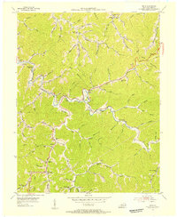
1954 Map of Meta
USGS Topo · Published 1955About this map
Johns Creek snakes through the center of this Pike County landscape, serving as the primary corridor for settlement and early mountain infrastructure in the mid-1950s. The map reveals a dense network of neighborhood schools and churches that once anchored these hollows, including the Johns Creek High Sch and the Zebulon PO. In this era, small-scale rural education was still decentralized, evidenced by local landmarks like the Tom Ray Sch and Bent Branch Sch positioned along narrow valley floors. Transportation is dominated by KY 119 and countless winding branches such as Brushy Fork and Sycamore Creek, while high ridges like Bent Mountain and Ford Mountain isolate the various forks. Genealogists will find a wealth of family-named landmarks, from the Williamson Cem to the Howard Cem, tracing the kinship ties of the region's inhabitants.
Find a feature on this map
93 named features on this map. Tap any name to fly to it.
Don’t see what you’re looking for? This feature index may not catch every label — zoom into the map to look around manually.
Map Details
Editions of this 1954 Meta Map
2 editions found
Other maps of this area

1886 · Prestonsburg
USGS Topo · 1:125,000

1886 · Grundy
USGS Topo · 1:125,000

1887 · Warfield
USGS Topo · 1:125,000

1890 · Whitesburg
USGS Topo · 1:125,000

1890 · Grundy
USGS Topo · 1:125,000

1891 · Warfield
USGS Topo · 1:125,000

1892 · Grundy
USGS Topo · 1:125,000

1892 · Whitesburg
USGS Topo · 1:125,000

1892 · Prestonsburg
USGS Topo · 1:125,000

1914 · Laynesville
USGS Topo · 1:48,000