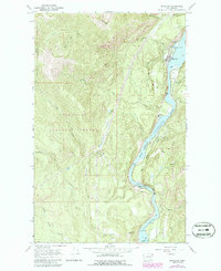
1967 Map of Metaline
USGS Topo · Published 1986About this map
The Pend Oreille River carves a deep valley through the northern reaches of the Colville National Forest in this late-1960s survey. The small community of Metaline serves as the focal point for the eastern riverbank, while the surrounding peaks, including Linton Mtn, Deer Mtn, and Cement Mtn, show the intensive industrial footprint of the era. This landscape is defined by its extraction history, featuring the Bella May Mine, Pocahontas, and the Wolf Mine, alongside several gravel pits and a quarry. Educational and civic infrastructure are represented by the Selkirk High Sch and a local Substation, while the Perkins Cem provides a genealogical touchstone for researchers. The presence of a Flume and an Aqueduct near the Smith Fork Flume Creek highlights the complex water management required for the region's mining and power operations during this period of mid-century development.
Find a feature on this map
42 named features on this map. Tap any name to fly to it.
Don’t see what you’re looking for? This feature index may not catch every label — zoom into the map to look around manually.
Map Details
Editions of this 1967 Metaline Map
3 editions found

Other maps of this area

1929 · Colville
USGS Topo · 1:125,000

1933 · Colville
USGS Topo · 1:125,000

1934 · Metaline
USGS Topo · 1:125,000

1942 · Metaline
USGS Topo · 1:125,000

1952 · Deep Lake
USGS Topo · 1:24,000

1952 · Leadpoint
USGS Topo · 1:24,000

1958 · Sandpoint
USGS Topo · 1:250,000

1963 · Sandpoint
USGS Topo · 1:250,000
1967 · Aladdin Mtn
USGS Topo · 1:24,000

1967 · Ione
USGS Topo · 1:24,000