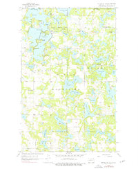
1956 Map of Metigoshe Lake
USGS Topo · Published 1976About this map
The Turtle Mountains dominate this landscape along the international boundary, where the Lake Metigoshe State Park straddles a labyrinth of glacial lakes and islands. This mid-century survey reveals a community deeply rooted around the water, with public spaces like Masonic Island and named landmarks such as Rugby Point and Squaw Pt defining the shoreline. The distribution of rural infrastructure across the townships of Roland and Homen suggests a settled agricultural and recreational pattern, evidenced by the numerous district schools including Hilton Sch No 3 and Loon Lake Sch No 5. Away from the central lake, smaller water bodies like Sivertson Lake and Lee Lake punctuate the wooded hills. The presence of Vinje Ch and Norland Ch marks the social centers for the surrounding homesteads in the decades following the initial settlement of Bottineau County.
Find a feature on this map
48 named features on this map. Tap any name to fly to it.
Don’t see what you’re looking for? This feature index may not catch every label — zoom into the map to look around manually.
Map Details
Editions of this 1956 Metigoshe Lake Map
2 editions found
Other maps of this area

1935 · Dunseith
USGS Topo · 1:48,000

1939 · Dunseith
USGS Topo · 1:62,500

1954 · Minot
USGS Topo · 1:250,000

1955 · Lords Lake
USGS Topo · 1:24,000

1955 · Bottineau
USGS Topo · 1:24,000

1955 · Bottineau SE
USGS Topo · 1:24,000

1956 · Metigoshe Lake
USGS Topo · 1:24,000

1956 · Lake McArthur
USGS Topo · 1:24,000
1956 · Lords Lake
USGS Topo · 1:25,000

1958 · Minot
USGS Topo · 1:250,000