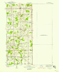
1940 Map of Metz
USGS Topo · Published 1940About this map
Metz and Alvarado anchor this 1938 survey of the rural landscape where Indiana meets Ohio and Michigan. The terrain is defined by a complex network of waterways and drainage, including Fish Creek, the Wabash River, and Black Creek. Numerous named bridges, such as Anspaugh Bridge and Enfield Bridge, reveal the vital crossing points of the era. The map is particularly rich for genealogical research, documenting several local houses of worship like Mt Pleasant Church and Bethel Church, alongside the Metz Cemetery and Eddy Cemetery. This corner of Steuben County shows a well-established agrarian community organized within York, Richland, and Franklin townships, featuring landmarks like the Tamarack School and Burdick Lake.
Find a feature on this map
31 named features on this map. Tap any name to fly to it.
Don’t see what you’re looking for? This feature index may not catch every label — zoom into the map to look around manually.
Map Details
Editions of this 1940 Metz Map
2 editions found
Other maps of this area

1914 · Pioneer
USGS Topo · 1:62,500

1914 · Bryan
USGS Topo · 1:62,500

1939 · Hamilton
USGS Topo · 1:24,000

1939 · Angola East
USGS Topo · 1:24,000

1939 · Clear Lake
USGS Topo · 1:24,000

1940 · Metz
USGS Topo · 1:24,000

1940 · Clear Lake
USGS Topo · 1:24,000

1943 · Bryan
USGS Topo · 1:62,500

1944 · Pioneer
USGS Topo · 1:62,500

1947 · Angola East
USGS Topo · 1:24,000