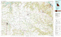
1986 Map of Mexico
USGS Topo · Published 1990About this map
Mexico serves as a central hub in this mid-1980s landscape, where the agricultural plains of Audrain County meet the rising hills of the Cuivre River valley. The map documents a period of significant regional water management, dominated by the sprawling reaches of Mark Twain Lake and the Mark Twain State Park in the northwest. To the east, the terrain descends toward the Mississippi River at Louisiana, a riverfront marked by the intersection of US Highway 54 and the Chicago and North Western Railway. These transportation corridors, including the Norfolk and Western Railway, define the settlement patterns of towns like Laddonia and Vandalia. Researchers can trace the layout of small crossroads such as Basinger Corner and Rush Hill, while several state wildlife areas, including Ted Shanks State Wildlife Management Area, illustrate the dedication of large tracts to conservation and floodplain management during this era.
Find a feature on this map
71 named features on this map. Tap any name to fly to it.
Don’t see what you’re looking for? This feature index may not catch every label — zoom into the map to look around manually.
Map Details
Editions of this 1986 Mexico Map
2 editions found
Other maps of this area

1886 · Jefferson City
USGS Topo · 1:125,000

1890 · Louisiana
USGS Topo · 1:125,000

1890 · Mexico
USGS Topo · 1:125,000

1890 · Moberly
USGS Topo · 1:125,000

1890 · Hermann
USGS Topo · 1:125,000

1890 · Fulton
USGS Topo · 1:125,000

1894 · Jefferson City
USGS Topo · 1:125,000

1903 · O'Fallon
USGS Topo · 1:125,000

1903 · Palmyra
USGS Topo · 1:125,000

1926 · Pittsfield
USGS Topo · 1:62,500