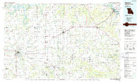
1986 Map of Mexico
USGS Topo · Published 1986About this map
The South Fork Salt River, Middle Fork Salt River, and North Fork Salt River converge into Mark Twain Lake, a prominent feature in this mid-1980s landscape. This region of East Central Missouri is defined by its agricultural grid and the rail corridors of the Central Illinois and Western and Norfolk and Western railroads. Smaller settlements like Laddonia, Farber, and Rush Hill dot the prairie between the larger hubs of Mexico and Vandalia. To the east, the terrain shifts as it approaches the Mississippi River at Louisiana, where the riverine environment contrasts with the upland plains. Named points of interest such as the Mexico Memorial Airport and several state wildlife areas, including Mark Twain State Park and the Ranacker State Wildlife Area, indicate a mix of municipal development and preserved natural spaces.
Find a feature on this map
119 named features on this map. Tap any name to fly to it.
Don’t see what you’re looking for? This feature index may not catch every label — zoom into the map to look around manually.
Map Details
Editions of this 1986 Mexico Map
2 editions found
Other maps of this area

1886 · Jefferson City
USGS Topo · 1:125,000

1890 · Louisiana
USGS Topo · 1:125,000

1890 · Mexico
USGS Topo · 1:125,000

1890 · Moberly
USGS Topo · 1:125,000

1890 · Hermann
USGS Topo · 1:125,000

1890 · Fulton
USGS Topo · 1:125,000

1894 · Jefferson City
USGS Topo · 1:125,000

1903 · O'Fallon
USGS Topo · 1:125,000

1903 · Palmyra
USGS Topo · 1:125,000

1926 · Pittsfield
USGS Topo · 1:62,500