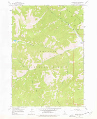
1963 Map of Meyers Cove
USGS Topo · Published 1978About this map
Meyers Cove sits at the confluence of several mountain drainages within the high-country border of the Salmon National Forest and Challis National Forest. The landscape is dominated by the deeply incised valleys of Camas Creek and the West Fork Camas Creek, reflecting an era of active mineral exploration in the Salmon River Mountains. Evidence of mid-century mining interest is scattered across the high ridges, including the Red Spar Mine and Big Lead Mine, along with a solitary Prospect near Hammer Creek. The map shows a transition from the light-duty road serving the settlement to an rugged Jeep Trail that climbs toward Fluorspar Ridge, tracing the path of the regional fluorspar mining boom. These remote camps and trails provide a detailed look at the infrastructure required to access isolated claims along Fluorspar Gulch and Antler Ridge during the 1950s and 1960s.
Find a feature on this map
26 named features on this map. Tap any name to fly to it.
Don’t see what you’re looking for? This feature index may not catch every label — zoom into the map to look around manually.
Map Details
Editions of this 1963 Meyers Cove Map
2 editions found
Other maps of this area

1930 · Casto
USGS Topo · 1:125,000

1956 · Twin Peaks
USGS Topo · 1:62,500

1957 · Challis
USGS Topo · 1:250,000

1960 · Challis
USGS Topo · 1:250,000

1963 · Challis
USGS Topo · 1:250,000

1963 · Meyers Cove
USGS Topo · 1:24,000

1963 · Rock Creek
USGS Topo · 1:24,000
1963 · Aparejo Point
USGS Topo · 1:24,000
1963 · Yellowjacket
USGS Topo · 1:24,000
1963 · Duck Creek Point
USGS Topo · 1:24,000