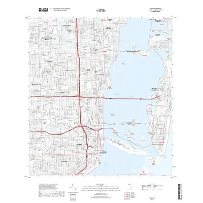
2018 Map of Miami
USGS Topo · Published 2018About this map
The Miami River serves as the arterial heart of this landscape, carving through the city to meet the expanse of Biscayne Bay. The dense urban fabric of Miami and Miami Beach is revealed in meticulous detail, showcasing the complex geometry of the Venetian Islands and the strategic positioning of Fisher Island at Government Cut. Long-established neighborhoods like Shenandoah, Allapattah, and Brownsville occupy the mainland, while the shoreline is defined by the heavy maritime infrastructure of Dodge Island and the Main Channel. Significant local history is preserved in the numerous burial grounds scattered across the quadrangle, from the historic City Cem to the sprawling Lincoln Memorial Park and Woodlawn Park Cem. This modern survey illustrates how the city has integrated its residential districts with massive engineering projects like the Mac Arthur Cswy and the intricate canal systems of the Little River Canal and Biscayne Canal.
Find a feature on this map
110 named features on this map. Tap any name to fly to it.
Don’t see what you’re looking for? This feature index may not catch every label — zoom into the map to look around manually.
Map Details
Editions of this 2018 Miami Map
This is the sole edition of this map. No revisions or reprints were ever made.
Other maps of this area

1947 · North Miami
USGS Topo · 1:24,000

1947 · Key Biscayne
USGS Topo · 1:24,000

1949 · Opalocka
USGS Topo · 1:24,000

1949 · Key Biscayne
USGS Topo · 1:24,000

1950 · Hialeah
USGS Topo · 1:24,000

1950 · Miami
USGS Topo · 1:24,000

1950 · North Miami
USGS Topo · 1:24,000

1950 · South Miami
USGS Topo · 1:24,000

1956 · South Miami
USGS Topo · 1:24,000

1956 · Miami
USGS Topo · 1:250,000