
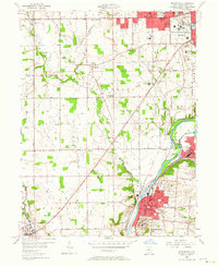
1955 Map of Miamisburg
USGS Topo · Published 1956About this map
The Miami River corridor south of Dayton defines the layout of this mid-century landscape, where industrial activity and residential expansion meet historic landmarks. The Miamisburg Mound State Memorial Park stands as a prominent feature within Miamisburg, a city served by the Baltimore and Ohio and New York Central railroads. The map records several small communities and residential developments like Whitfield, Frytown, and Ridgewood Heights during a period of suburban growth. To the north, the sprawling Veterans Administration Center and the Dayton Correction Farm occupy significant acreage, while local recreation is represented by the Dayton Speedway. Rural character persists in the west with numerous family cemeteries such as Trissel Cem and Forney Cem, alongside country congregations at St Peters Ch and Salem Churches along the banks of Bear Creek.
Find a feature on this map
52 named features on this map. Tap any name to fly to it.
Don’t see what you’re looking for? This feature index may not catch every label — zoom into the map to look around manually.
Map Details
Editions of this 1955 Miamisburg Map
2 editions found
Other maps of this area

1904 · Dayton
USGS Topo · 1:62,500

1905 · Brookville
USGS Topo · 1:62,500

1906 · Dayton
USGS Topo · 1:62,500

1908 · Miamisburg
USGS Topo · 1:62,500

1913 · Waynesville
USGS Topo · 1:62,500

1915 · Waynesville
USGS Topo · 1:62,500

1951 · Franklin
USGS Topo · 1:24,000

1953 · Cincinnati
USGS Topo · 1:250,000

1955 · Dayton South
USGS Topo · 1:24,000
1955 · Springboro
USGS Topo · 1:24,000