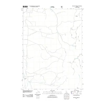
2011 Map of Michaud Creek
USGS Topo · Published 2011About this map
Howard Mountain and the high desert terrain of southern Idaho anchor this topographic study of the western flank of the Portneuf Range. The landscape is defined by its vital water sources and seasonal drainages, which have historically dictated the placement of roads and homesteads in the high country. Essential landmarks for stockmen and early travelers are clearly marked, including Wildcat Spring, Outlaw Spring, and the uniquely named Dead Cow Spring.
Find a feature on this map
17 named features on this map. Tap any name to fly to it.
Don’t see what you’re looking for? This feature index may not catch every label — zoom into the map to look around manually.
Map Details
Editions of this 2011 Michaud Creek Map
This is the sole edition of this map. No revisions or reprints were ever made.
Other maps of this area

1934 · Michaud
USGS Topo · 1:62,500

1937 · Pocatello
USGS Topo · 1:48,000

1937 · Michaud
USGS Topo · 1:62,500

1938 · Pauline
USGS Topo · 1:48,000

1944 · Pocatello
USGS Topo · 1:62,500

1944 · Arbon
USGS Topo · 1:62,500

1954 · Pocatello
USGS Topo · 1:250,000

1958 · Pocatello
USGS Topo · 1:250,000

1968 · Clifton Creek
USGS Topo · 1:24,000
1971 · Pocatello North
USGS Topo · 1:24,000