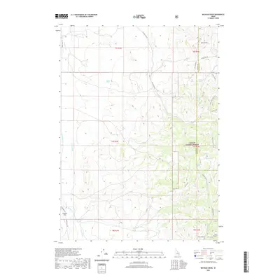
2020 Map of Michaud Creek
USGS Topo · Published 2020About this map
Caribou National Forest dominates the eastern hills of this Idaho landscape, where the high ridges of Howard Mtn give way to a complex drainage system feeding the Arbon Valley. In the lower elevations to the west, water management is evident through features like the Tyhee Canal and the School Lateral, highlighting the irrigation infrastructure necessary for the valley's agricultural operations. The terrain is marked by distinctive natural landmarks such as Eagletail Rock and numerous water sources including Wildcat Spring, Dead Cow Spring, and the high-elevation Horse Lake. Transportation across this Power and Bannock County border area is defined by the winding Michaud Creek Rd and the Old Arbon Hwy, which trace the base of the foothills. For those researching the area's development, the map details the network of creeks like Birch Creek and Midnight Creek that have historically shaped local land use.
Find a feature on this map
37 named features on this map. Tap any name to fly to it.
Don’t see what you’re looking for? This feature index may not catch every label — zoom into the map to look around manually.
Map Details
Editions of this 2020 Michaud Creek Map
This is the sole edition of this map. No revisions or reprints were ever made.
Other maps of this area

1934 · Michaud
USGS Topo · 1:62,500

1937 · Pocatello
USGS Topo · 1:48,000

1937 · Michaud
USGS Topo · 1:62,500

1938 · Pauline
USGS Topo · 1:48,000

1944 · Pocatello
USGS Topo · 1:62,500

1944 · Arbon
USGS Topo · 1:62,500

1954 · Pocatello
USGS Topo · 1:250,000

1958 · Pocatello
USGS Topo · 1:250,000

1968 · Clifton Creek
USGS Topo · 1:24,000
1971 · Pocatello North
USGS Topo · 1:24,000