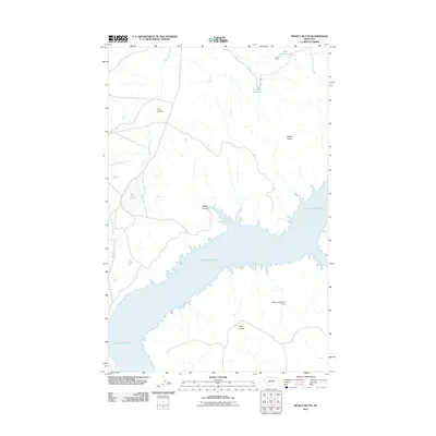
2011 Map of Mickey Butte
USGS Topo · Published 2011About this map
Fort Peck Lake dominates the central landscape of this Garfield County quadrangle, where the complex shoreline of the reservoir meets the Missouri River breaks. The terrain is defined by a series of drainage systems and high points, including the prominent Mickey Butte and the watershed marker of Tripp Divide. Water management is evident through numerous small impoundments such as Mary Reservoir, held by Mary Dam, and the Stratton Reservoir Dam further south. These features suggest a landscape tailored for livestock grazing in an arid environment. Historic ranching footprints are reflected in named localities like Mickus Bottom and Mickus Coulee. Narrow seasonal waterways, including Valentine Creek and Jim Wells Creek, snake through the coulees toward the main lake, while features like Dry Lake underscore the ephemeral nature of water in this part of Montana.
Find a feature on this map
13 named features on this map. Tap any name to fly to it.
Don’t see what you’re looking for? This feature index may not catch every label — zoom into the map to look around manually.
Map Details
Editions of this 2011 Mickey Butte Map
This is the sole edition of this map. No revisions or reprints were ever made.
Other maps of this area

1954 · Jordan
USGS Topo · 1:250,000

1956 · Jordan
USGS Topo · 1:250,000

1958 · Jordan
USGS Topo · 1:250,000

1964 · Jordan
USGS Topo · 1:250,000

1965 · Germaine Coulee East
USGS Topo · 1:24,000

1965 · Germaine Coulee West
USGS Topo · 1:24,000

1965 · Lost Creek
USGS Topo · 1:24,000

1965 · Herman Point
USGS Topo · 1:24,000

1965 · Locke Ranch
USGS Topo · 1:24,000

1965 · Cap Rock Butte
USGS Topo · 1:24,000