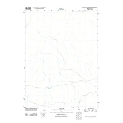
2012 Map of Middle Draw Reservoir
USGS Topo · Published 2012About this map
Middle Draw Reservoir serves as a central landmark in this drainage basin of Nevada's high desert. The map captures a landscape defined by intermittent water flow and cattle ranching infrastructure at the start of the 2010s. Northward-flowing drainages including Threemile Creek and Winters Creek carve through the basin, eventually converging as they move toward the Owyhee River system. The presence of local roads and the reservoir suggest a land use centered on livestock management and water conservation in a region where every stream, including Chimney Creek, is vital to the local ecology and economy. This survey provides a clear look at the hydraulic patterns and transport routes used by Elko County residents before more recent environmental shifts.
Find a feature on this map
4 named features on this map. Tap any name to fly to it.
Don’t see what you’re looking for? This feature index may not catch every label — zoom into the map to look around manually.
Map Details
Editions of this 2012 Middle Draw Reservoir Map
This is the sole edition of this map. No revisions or reprints were ever made.
Other maps of this area

1955 · McDermitt
USGS Topo · 1:250,000

1956 · Mt. Blitzen
USGS Topo · 1:62,500

1959 · McDermitt
USGS Topo · 1:250,000

1964 · Wilson Reservoir
USGS Topo · 1:62,500

1974 · Soldier Cap
USGS Topo · 1:24,000

1974 · Middle Draw Reservoir
USGS Topo · 1:24,000

1974 · Winters Ranch Reservoir
USGS Topo · 1:24,000

1974 · Burner Hills
USGS Topo · 1:24,000

1974 · Desert Ranch
USGS Topo · 1:24,000
1977 · Silver Lake
USGS Topo · 1:24,000