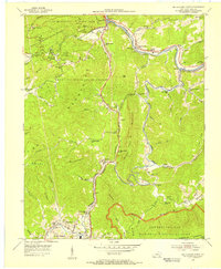
1954 Map of Middlesboro North
USGS Topo · Published 1956About this map
Pine Mountain State Park and the Kentucky Ridge State Forest dominate this mid-century landscape in Bell County, where industrial development and conservation efforts overlap. The Louisville and Nashville Railroad winds along the Cumberland River and Yellow Creek, serving coal-focused communities like Wasioto, Meldrum, and Ferndale. Evidence of the region's extraction economy is visible through the presence of strip mines located near Binghamtown and Middlesboro in the southern portion of the sheet. Local social structures are clearly defined by numerous mountainside institutions, including the County High Sch, the County Infirmary, and many small congregations such as Ward Chapel Sch and Old Cannon Creek Ch. To the southeast, the nascent Cumberland Gap National Historical Park preserves the corridor where the Wilderness Road once guided pioneers through the gap.
Find a feature on this map
100 named features on this map. Tap any name to fly to it.
Don’t see what you’re looking for? This feature index may not catch every label — zoom into the map to look around manually.
Map Details
Editions of this 1954 Middlesboro North Map
This is the sole edition of this map. No revisions or reprints were ever made.
Other maps of this area

1886 · Cumberland Gap
USGS Topo · 1:125,000

1888 · Cumberland Gap
USGS Topo · 1:125,000

1891 · Cumberland Gap
USGS Topo · 1:125,000

1903 · Pineville
USGS Topo · 1:48,000

1903 · Middlesboro
USGS Topo · 1:48,000

1927 · Middlesboro
USGS Topo · 1:62,500

1930 · Middlesboro
USGS Topo · 1:62,500

1935 · Varilla
USGS Topo · 1:24,000

1935 · Mingo Mountains
USGS Topo · 1:24,000

1935 · Cumberland Gap
USGS Topo · 1:24,000