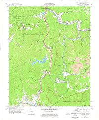
1974 Map of Middlesboro North
USGS Topo · Published 1977About this map
Pine Mountain and the Log Mountains dominate this 1970s landscape, where the coal industry and natural preservation exist side-by-side. The Cumberland River carves a winding path through the north, while the Louisville and Nashville railroad follows the water gaps to serve the region's heavy industry. This era shows extensive strip mine activity across the ridges, particularly around Rocky Face and the Log Mountains.
Find a feature on this map
104 named features on this map. Tap any name to fly to it.
Don’t see what you’re looking for? This feature index may not catch every label — zoom into the map to look around manually.
Map Details
Editions of this 1974 Middlesboro North Map
This is the sole edition of this map. No revisions or reprints were ever made.
Other maps of this area

1886 · Cumberland Gap
USGS Topo · 1:125,000

1888 · Cumberland Gap
USGS Topo · 1:125,000

1891 · Cumberland Gap
USGS Topo · 1:125,000

1903 · Pineville
USGS Topo · 1:48,000

1903 · Middlesboro
USGS Topo · 1:48,000

1927 · Middlesboro
USGS Topo · 1:62,500

1930 · Middlesboro
USGS Topo · 1:62,500

1935 · Varilla
USGS Topo · 1:24,000

1935 · Mingo Mountains
USGS Topo · 1:24,000

1935 · Cumberland Gap
USGS Topo · 1:24,000