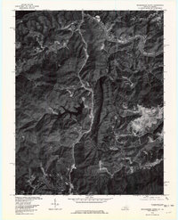
1976 Map of Middlesboro North
USGS Topo · Published 1981About this map
Cumberland River corridor activity dominates this 1976 orthophotomap of Bell County, showing the intersection of heavy industry and narrow Appalachian valleys. This aerial perspective, prepared by the Geological Survey, reveals the intensive land use around the northern outskirts of Middlesboro. The imagery clearly distinguishes between the undisturbed forested ridges and the high-contrast footprints of resource extraction and transit infrastructure that define the region's economy.
Find a feature on this map
13 named features on this map. Tap any name to fly to it.
Don’t see what you’re looking for? This feature index may not catch every label — zoom into the map to look around manually.
Map Details
Editions of this 1976 Middlesboro North Map
This is the sole edition of this map. No revisions or reprints were ever made.
Other maps of this area

1886 · Cumberland Gap
USGS Topo · 1:125,000

1888 · Cumberland Gap
USGS Topo · 1:125,000

1891 · Cumberland Gap
USGS Topo · 1:125,000

1903 · Pineville
USGS Topo · 1:48,000

1903 · Middlesboro
USGS Topo · 1:48,000

1927 · Middlesboro
USGS Topo · 1:62,500

1930 · Middlesboro
USGS Topo · 1:62,500

1935 · Varilla
USGS Topo · 1:24,000

1935 · Mingo Mountains
USGS Topo · 1:24,000

1935 · Cumberland Gap
USGS Topo · 1:24,000