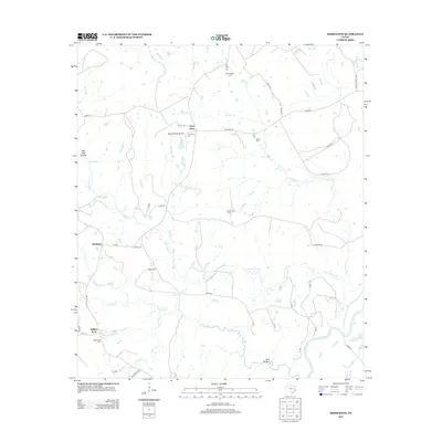
2013 Map of Middleton
USGS Topo · Published 2013About this map
Guys Store and Spillers Store serve as primary landmarks for this rural corner of Leon County, where the landscape is defined by the winding course of Lower Keechi Cr and its many tributaries. The area's settlement history is preserved through a high concentration of family and community burial grounds, including New Salem Cem, Thomason Cem, and Spillerville Cem. The southern boundary of the map follows the meandering Trinity River, which historically dictated the movement of goods and people through the region. Transportation is facilitated by a network of farm roads and county routes like Alabama Rd and FM-811, which connect small hubs like Cairomiss to the surrounding cattle and timber lands. The inclusion of Moore Ranch Airport highlights a transition to private aviation infrastructure amidst the traditional agrarian backdrop of Red Oak Hollow and Twomile Cr.
Find a feature on this map
58 named features on this map. Tap any name to fly to it.
Don’t see what you’re looking for? This feature index may not catch every label — zoom into the map to look around manually.
Map Details
Editions of this 2013 Middleton Map
This is the sole edition of this map. No revisions or reprints were ever made.
Other maps of this area

1953 · Palestine
USGS Topo · 1:250,000

1957 · Palestine
USGS Topo · 1:250,000

1964 · Sand Ridge
USGS Topo · 1:24,000

1964 · Austonio
USGS Topo · 1:24,000

1964 · Centerville
USGS Topo · 1:24,000

1964 · Eunice
USGS Topo · 1:24,000

1964 · Middleton
USGS Topo · 1:24,000

1964 · Halls Bluff
USGS Topo · 1:24,000

1964 · Leona
USGS Topo · 1:24,000
1964 · Elwood
USGS Topo · 1:24,000