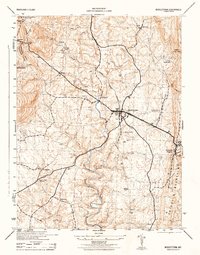
1944 Map of Middletown
USGS Topo · Published 1944About this map
Middletown Valley is the focal point of this 1944 Army Corps of Engineers survey, showing a landscape defined by small agrarian settlements and the steep rise of Catoctin Mountain to the east. The village of Middletown serves as the central hub, with a network of secondary roads connecting outlying hamlets like Spoolsville, Arnoldtown, and Harmony. Along the ridges of South Mountain at the western edge, commemorative landmarks like the Major General Reno Monument and Washington Monument State Park stand near Turners Gap, marking points of significant local and national history. The drainage of Catoctin Creek and Middle Creek dictates the placement of mills and farmsteads, while the Middletown Reservoir provides a clear look at mid-century local infrastructure. Genealogists and historians can find specific rural churches and burial grounds, such as Mt Tabor Church and Pleasant View Church, which anchored these scattered communities during the war years.
Find a feature on this map
31 named features on this map. Tap any name to fly to it.
Don’t see what you’re looking for? This feature index may not catch every label — zoom into the map to look around manually.
Map Details
Editions of this 1944 Middletown Map
2 editions found
Other maps of this area

1884 · Harpers Ferry
USGS Topo · 1:125,000

1891 · Harpers Ferry
USGS Topo · 1:125,000

1893 · Frederick
USGS Topo · 1:125,000

1893 · Harpers Ferry
USGS Topo · 1:125,000

1894 · Frederick
USGS Topo · 1:125,000

1908 · Middletown
USGS Topo · 1:48,000

1908 · Ijamsville
USGS Topo · 1:62,500

1909 · Ijamsville
USGS Topo · 1:62,500

1909 · Hagerstown
USGS Topo · 1:48,000

1910 · Antietam
USGS Topo · 1:62,500