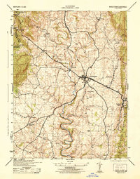
1944 Map of Middletown
USGS Topo · Published 1944About this map
Middletown serves as the central hub for this portion of the Middletown Valley, where a dense network of roads converges near the Middletown Reservoir. The landscape is defined by the significant rise of South Mountain to the west and Catoctin Mountain to the east, creating a corridor of fertile bottomland carved by Catoctin Creek and Middle Creek. This 1944 survey reveals a mix of agricultural hamlets and early recreational landmarks, such as Washington Monument State Park and Gambrill State Park. Local history and genealogy are anchored by rural centers like Frostown, Bolivar, and Arnoldtown, alongside prominent religious and memorial sites including Mt Tabor Church and the Major General Reno Monument at Fox Gap. The presence of several fords and numerous benchmarks suggests a well-traversed rural economy transitioning into the mid-century era.
Find a feature on this map
29 named features on this map. Tap any name to fly to it.
Don’t see what you’re looking for? This feature index may not catch every label — zoom into the map to look around manually.
Map Details
Editions of this 1944 Middletown Map
2 editions found
Other maps of this area

1884 · Harpers Ferry
USGS Topo · 1:125,000

1891 · Harpers Ferry
USGS Topo · 1:125,000

1893 · Frederick
USGS Topo · 1:125,000

1893 · Harpers Ferry
USGS Topo · 1:125,000

1894 · Frederick
USGS Topo · 1:125,000

1908 · Middletown
USGS Topo · 1:48,000

1908 · Ijamsville
USGS Topo · 1:62,500

1909 · Ijamsville
USGS Topo · 1:62,500

1909 · Hagerstown
USGS Topo · 1:48,000

1910 · Antietam
USGS Topo · 1:62,500