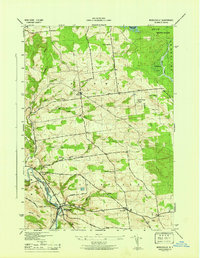
1946 Map of Middleville
USGS Topo · Published 1946About this map
Middleville and the surrounding townships of Fairfield and Norway are documented here during the immediate post-war era, showing a landscape defined by upland dairy farming and the winding valley of West Canada Creek. The map provides detailed placement of rural institutions, including the Hardscrabble Cem and several local education centers like School No 2 and School No 7. The presence of the Lookout Tower Dairy 1812 on a prominent elevation suggests the historical importance of fire observation and surveying in these highlands near the Adirondack State Park boundary.
Find a feature on this map
38 named features on this map. Tap any name to fly to it.
Don’t see what you’re looking for? This feature index may not catch every label — zoom into the map to look around manually.
Map Details
Editions of this 1946 Middleville Map
This is the sole edition of this map. No revisions or reprints were ever made.
Other maps of this area

1897 · Remsen
USGS Topo · 1:62,500

1898 · Utica
USGS Topo · 1:62,500

1900 · Little Falls
USGS Topo · 1:62,500

1900 · Utica
USGS Topo · 1:62,500

1900 · Remsen
USGS Topo · 1:62,500

1900 · Wilmurt
USGS Topo · 1:62,500

1902 · Wilmurt
USGS Topo · 1:62,500

1903 · Little Falls
USGS Topo · 1:62,500

1939 · Little Falls
USGS Topo · 1:62,500

1943 · Newport
USGS Topo · 1:24,000