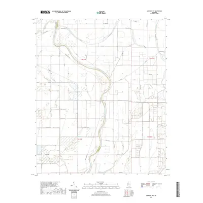
2020 Map of Midnight NW
USGS Topo · Published 2020About this map
The Big Sunflower River winds through the heart of this alluvial landscape, marking the boundary between Washington and Humphreys counties. This delta region is defined by an intricate network of slow-moving waterways, including Bogue Phalia, Beasley Bayou, and Mills Bayou. The surveyor's grid is etched onto the terrain by numerous rural roads such as Avon-Darlove Rd, Sunflower River Rd, and McCullum Rd, which follow the section lines and natural levees. The drainage pattern, highlighted by Pitchlow Bayou and Buck Bayou, illustrates the complex hydrologic history of the Yazoo Basin, where subtle elevation changes dictate the flow of water and the placement of agricultural infrastructure.
Find a feature on this map
41 named features on this map. Tap any name to fly to it.
Don’t see what you’re looking for? This feature index may not catch every label — zoom into the map to look around manually.
Map Details
Editions of this 2020 Midnight NW Map
This is the sole edition of this map. No revisions or reprints were ever made.
Other maps of this area

1939 · Tralake
USGS Topo · 1:62,500

1939 · Swan Lake
USGS Topo · 1:62,500

1940 · Auter
USGS Topo · 1:62,500

1940 · Baird
USGS Topo · 1:62,500

1953 · Greenwood
USGS Topo · 1:250,000

1956 · Greenwood
USGS Topo · 1:250,000
1965 · Richey
USGS Topo · 1:24,000
1965 · Midnight
USGS Topo · 1:24,000

1965 · Inverness
USGS Topo · 1:24,000

1965 · Kinlock
USGS Topo · 1:24,000