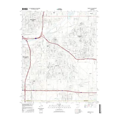
2016 Map of Midwest City
USGS Topo · Published 2016About this map
Midwest City and Del City anchor this 2016 survey, showcasing the dense residential and military-industrial expansion east of Oklahoma City. The sprawling footprint of the Tinker AFB Runways dominates the eastern landscape, serving as a primary driver for the surrounding urban grid. The map captures smaller incorporated enclaves like Smith Village and Midway Village, which maintain their distinct boundaries despite the encroaching metropolitan growth. The North Canadian River and its tributaries, including Crutcho Cr and Crooked Oak Cr, provide the natural framework for the terrain. Educational and community hubs are well-documented, from the Rose State Coll campus to the Heritage Coll grounds. Farther south, the transition into Cleveland County is marked near the shores of Stanley Draper Lake, while historic burial sites like Sunny Lane Cem and Kuhlman Cem offer points of interest for local genealogists.
Find a feature on this map
31 named features on this map. Tap any name to fly to it.
Don’t see what you’re looking for? This feature index may not catch every label — zoom into the map to look around manually.
Map Details
Editions of this 2016 Midwest City Map
This is the sole edition of this map. No revisions or reprints were ever made.
Other maps of this area

1892 · Moore
USGS Topo · 1:62,500

1892 · Edmond
USGS Topo · 1:62,500

1892 · Kingfisher
USGS Topo · 1:125,000

1893 · Oklahoma City
USGS Topo · 1:62,500

1895 · Kingfisher
USGS Topo · 1:125,000

1898 · Purcell
USGS Topo · 1:125,000

1904 · Chickasha
USGS Topo · 1:125,000

1934 · Crutcho Creek
USGS Topo · 1:24,000

1934 · Moore
USGS Topo · 1:62,500

1935 · Spencer
USGS Topo · 1:24,000