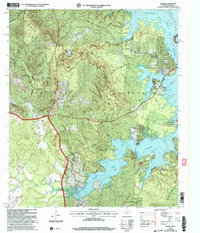
2003 Map of Milam
USGS Topo · Published 2004About this map
The Sabine National Forest dominates this landscape along the eastern edge of Texas, where the terrain slopes toward the expansive Toledo Bend Reservoir. The historic path of El Camino Real cuts through the region, anchoring a network of roads that connect the community of Milam with lakeside developments like Pendleton Harbor and Mid Lake Village. This survey illustrates the intricate drainage system of the forest floor, including Carrice Creek and the Palo Gaucho Bayou, which feed into the reservoir's deeply indented shoreline.
Find a feature on this map
44 named features on this map. Tap any name to fly to it.
Don’t see what you’re looking for? This feature index may not catch every label — zoom into the map to look around manually.
Map Details
Editions of this 2003 Milam Map
This is the sole edition of this map. No revisions or reprints were ever made.
Other maps of this area

1941 · Zwolle
USGS Topo · 1:62,500

1944 · Negreet
USGS Topo · 1:62,500

1944 · Patroon
USGS Topo · 1:62,500

1944 · Zwolle
USGS Topo · 1:62,500

1953 · Alexandria
USGS Topo · 1:250,000

1954 · Columbus
USGS Topo · 1:24,000

1954 · Negreet
USGS Topo · 1:62,500

1954 · Salter Creek
USGS Topo · 1:24,000

1955 · Alexandria
USGS Topo · 1:250,000

1956 · Patroon
USGS Topo · 1:62,500