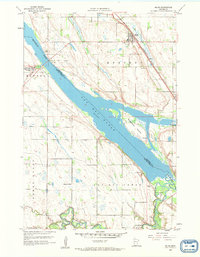
1958 Map of Milan
USGS Topo · Published 1959About this map
Lac qui Parle and the Minnesota River dominate the landscape of this 1950s survey, marking the intersection of Chippewa and Lac qui Parle counties. The village of Milan serves as the regional hub, situated along the Chicago Milwaukee St Paul and Pacific railroad line. The map captures the agricultural and community infrastructure of the mid-century, from the rural School No 836 to the Kviteseid Cem and Lac qui Parle Cem.
Find a feature on this map
20 named features on this map. Tap any name to fly to it.
Don’t see what you’re looking for? This feature index may not catch every label — zoom into the map to look around manually.
Map Details
Editions of this 1958 Milan Map
2 editions found

Other maps of this area

1953 · Milbank
USGS Topo · 1:250,000

1953 · Watertown
USGS Topo · 1:250,000

1953 · New Ulm
USGS Topo · 1:250,000

1953 · Saint Cloud
USGS Topo · 1:250,000

1957 · Saint Cloud
USGS Topo · 1:250,000

1957 · New Ulm
USGS Topo · 1:250,000

1958 · New Ulm
USGS Topo · 1:250,000

1958 · Milbank
USGS Topo · 1:250,000

1958 · Watertown
USGS Topo · 1:250,000

1958 · Saint Cloud
USGS Topo · 1:250,000