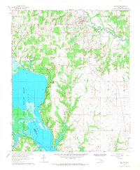
1967 Map of Milburn
USGS Topo · Published 1968About this map
Lake Texoma and the Washita River dominate the southwestern portion of this landscape, marking the confluence where river currents meet the expanding waters of the reservoir. This 1967 field-checked survey highlights the managed conservation lands of the Tishomingo National Wildlife Refuge, which spans the shoreline and includes features like Nida Point. Inland, the terrain is defined by a network of creeks including Twelvemile Creek, Sandy Creek, and Rock Creek, which drain the varied topography of areas labeled Thomas and Myrick.
Find a feature on this map
29 named features on this map. Tap any name to fly to it.
Don’t see what you’re looking for? This feature index may not catch every label — zoom into the map to look around manually.
Map Details
Editions of this 1967 Milburn Map
This is the sole edition of this map. No revisions or reprints were ever made.
Other maps of this area

1899 · Atoka
USGS Topo · 1:125,000

1900 · Atoka
USGS Topo · 1:125,000

1901 · Tishomingo
USGS Topo · 1:125,000

1957 · Ardmore
USGS Topo · 1:250,000

1963 · Ardmore
USGS Topo · 1:250,000
1967 · Tishomingo SW
USGS Topo · 1:24,000

1967 · Connerville SE
USGS Topo · 1:24,000

1967 · Tishomingo
USGS Topo · 1:24,000
1967 · Reagan
USGS Topo · 1:24,000
1967 · Little City
USGS Topo · 1:24,000