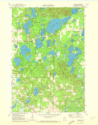
1970 Map of Mildred
USGS Topo · Published 1972About this map
The Mildred settlement and the Northern Pacific railroad corridor define the southern landscape of this 1970 survey. This part of Cass County is characterized by an intricate network of interconnected glacial lakes and wetland systems, including Big Portage Lake, Hattie Lake, and the uniquely named Oz Yoke Lake. The mapping reveals a transition in land use, from the established Pine River Cem near the townsite to the recreation-focused Public Access points on Lindsey Lake. Notable for local researchers is the Chickamaw Beach Corporate Bdy, which marks the jurisdictional boundaries within the township of Barclay. The presence of a Gravel Pit and scattered sandpits indicates the local extraction industry that operated alongside the region's prominent timber and rail infrastructure during the late twentieth century.
Find a feature on this map
53 named features on this map. Tap any name to fly to it.
Don’t see what you’re looking for? This feature index may not catch every label — zoom into the map to look around manually.
Map Details
Editions of this 1970 Mildred Map
2 editions found
Other maps of this area

1919 · Leader
USGS Topo · 1:62,500

1953 · Brainerd
USGS Topo · 1:250,000

1957 · Brainerd
USGS Topo · 1:250,000

1958 · Brainerd
USGS Topo · 1:250,000

1959 · Pine River
USGS Topo · 1:24,000

1959 · Jenkins
USGS Topo · 1:24,000

1965 · Brainerd
USGS Topo · 1:250,000

1970 · Backus
USGS Topo · 1:24,000

1970 · Hackensack
USGS Topo · 1:24,000
1970 · Bungo Creek
USGS Topo · 1:24,000