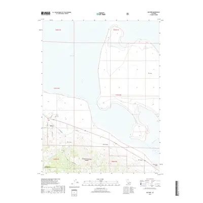
2018 Map of Milford
USGS Topo · Published 2018About this map
Milford sits at the base of the Sierra Nevada's northeastern escarpment, where the high timber of the Plumas National Forest meets the arid basin floor. This map illustrates the transition from the steep drainage of East Canyon and Stiles Canyon into the expansive Honey Lake Valley. The shoreline of Honey Lake dominates the northern portion of the quadrangle, featuring a unique geographic rise known as The Island. The settlement pattern follows the historic transit corridor of Old Hwy 395, which skirts the edge of the wetlands. Local infrastructure is represented by routes such as Milford Grade and Laufman Rd, serving as links between the agricultural valley and the mountainous forest lands. The map also delineates the boundary between Lassen and Plumas counties, providing a clear view of the regional topography and water systems including Mill Cr and Long Valley Cr.
Find a feature on this map
25 named features on this map. Tap any name to fly to it.
Don’t see what you’re looking for? This feature index may not catch every label — zoom into the map to look around manually.
Map Details
Editions of this 2018 Milford Map
This is the sole edition of this map. No revisions or reprints were ever made.
Other maps of this area

1886 · Honey Lake
USGS Topo · 1:250,000

1891 · Honey Lake
USGS Topo · 1:250,000

1893 · Honey Lake
USGS Topo · 1:250,000

1950 · Milford
USGS Topo · 1:62,500

1954 · Wendel
USGS Topo · 1:62,500

1954 · Litchfield
USGS Topo · 1:62,500

1954 · Doyle
USGS Topo · 1:62,500

1955 · Westwood
USGS Topo · 1:250,000

1958 · Westwood
USGS Topo · 1:250,000

1959 · Westwood
USGS Topo · 1:250,000