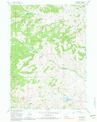
1956 Map of Milk Creek
USGS Topo · Published 1981About this map
Shoshone National Forest lands dominate the western portions of this 1950s survey, where the rugged topography is defined by the headwaters of Cottonwood Creek and Milk Creek. The map documents a working landscape of mid-century Wyoming cattle ranching and timber harvesting, marked by several remote outposts including LU Cow Camp, TA Cow Camp, and the Anderson Sawmill along Roach Creek. This era of land use is further evidenced by a scattered network of jeep trails and pack trails that provide the only access to the high interior country.
Find a feature on this map
39 named features on this map. Tap any name to fly to it.
Don’t see what you’re looking for? This feature index may not catch every label — zoom into the map to look around manually.
Map Details
Editions of this 1956 Milk Creek Map
3 editions found
Other maps of this area

1904 · Kirwin
USGS Topo · 1:125,000

1906 · Kirwin
USGS Topo · 1:125,000

1955 · Thermopolis
USGS Topo · 1:250,000

1956 · Milk Creek
USGS Topo · 1:24,000

1956 · Twentyone Creek
USGS Topo · 1:24,000

1956 · Soapy Dale Peak
USGS Topo · 1:24,000

1956 · Adam Weiss Peak
USGS Topo · 1:24,000

1958 · Thermopolis
USGS Topo · 1:250,000

1962 · Thermopolis
USGS Topo · 1:250,000
1965 · Eagle Nest Ranch
USGS Topo · 1:24,000