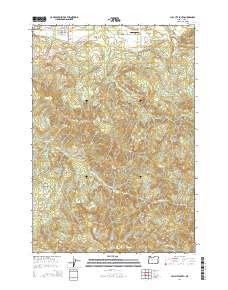
2014 Map of Mill City South
USGS Topo · Published 2014About this map
Mill City anchors the northern boundary of this landscape, where the residential grid of SE 4th Ave and SE Kingwood St transitions into the steep, timbered elevations of the Cascades. The map details a complex drainage network feeding into the Santiam River basin, with Thomas Cr and Rock Cr carving through the southern and central terrain. Cultural landmarks are concentrated along the northern roads, including the Fairview Cem and Davis Airport situated near Gates School Rd.
Find a feature on this map
32 named features on this map. Tap any name to fly to it.
Don’t see what you’re looking for? This feature index may not catch every label — zoom into the map to look around manually.
Map Details
Editions of this 2014 Mill City South Map
This is the sole edition of this map. No revisions or reprints were ever made.
Other maps of this area

1929 · Mill City
USGS Topo · 1:125,000

1951 · Lyons
USGS Topo · 1:62,500

1951 · Snow Peak
USGS Topo · 1:62,500

1953 · Salem
USGS Topo · 1:250,000

1954 · Salem
USGS Topo · 1:250,000

1955 · Mill City
USGS Topo · 1:62,500

1956 · Quartzville
USGS Topo · 1:62,500

1960 · Salem
USGS Topo · 1:250,000

1962 · Salem
USGS Topo · 1:250,000

1963 · Salem
USGS Topo · 1:250,000