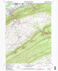
1965 Map of Mill Hall
USGS Topo · Published 1986About this map
Bald Eagle Mountain dominates the central landscape of this Clinton County survey, separating the industrial activity of the north from the agricultural valleys to the south. In the shadow of the mountain, the boroughs of Mill Hall and Flemington are defined by their proximity to Bald Eagle Creek and the Conrail rail line, which served a landscape of quarries and early industrial sites like the Industrial Waste Pond. Further south, the map reveals a shift into the rural Nittany Valley and Sugar Valley, where small clusters of settlement like Salona and Mackeyville are centered around local landmarks such as Cedar Hill Cemetery and the Lamar School. The southern reaches are heavily forested, containing portions of Bald Eagle State Forest and State Game Lands No 295, accessed by a network of paths including the Winter Riansares Trail.
Find a feature on this map
51 named features on this map. Tap any name to fly to it.
Don’t see what you’re looking for? This feature index may not catch every label — zoom into the map to look around manually.
Map Details
Editions of this 1965 Mill Hall Map
3 editions found
Other maps of this area

1921 · Howard
USGS Topo · 1:48,000

1921 · Lock Haven
USGS Topo · 1:62,500

1923 · Howard
USGS Topo · 1:62,500

1923 · Lock Haven
USGS Topo · 1:62,500

1924 · Centre Hall
USGS Topo · 1:62,500

1929 · Centre Hall
USGS Topo · 1:62,500

1937 · Millheim
USGS Topo · 1:48,000

1941 · Millheim
USGS Topo · 1:62,500

1943 · Lewistown
USGS Topo · 1:125,000

1944 · Lock Haven
USGS Topo · 1:62,500