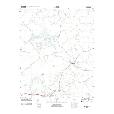
2010 Map of Mill Spring
USGS Topo · Published 2010About this map
Lake Adger dominates the northwestern portion of this landscape, formed by the Turner Shoals Dam along the Green River. This 2010 topographic survey documents the residential and agricultural layout of Polk County, radiating from settlements like Columbus and Mill Spring. The terrain is defined by significant elevations, including Tryon Peak, White Oak Mountain, and Little White Oak Mountain, which separate the river valleys from the southern lowlands.
Find a feature on this map
69 named features on this map. Tap any name to fly to it.
Don’t see what you’re looking for? This feature index may not catch every label — zoom into the map to look around manually.
Map Details
Editions of this 2010 Mill Spring Map
This is the sole edition of this map. No revisions or reprints were ever made.
Other maps of this area

1907 · Saluda
USGS Topo · 1:125,000

1935 · Batcave
USGS Topo · 1:24,000

1935 · Fishtop
USGS Topo · 1:24,000

1946 · Bat Cave
USGS Topo · 1:24,000

1946 · Cliffield Mtn
USGS Topo · 1:24,000
1947 · Bat Cave
USGS Topo · 1:24,000

1947 · Cliffield Mtn.
USGS Topo · 1:24,000

1955 · Knoxville
USGS Topo · 1:250,000

1957 · Knoxville
USGS Topo · 1:250,000

1959 · Lake Lure
USGS Topo · 1:62,500