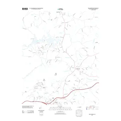
2013 Map of Mill Spring
USGS Topo · Published 2013About this map
Columbus serves as a primary hub in this portion of the Blue Ridge foothills, situated south of the prominent White Oak Mountain and Foster Mountain. The landscape is defined by the winding course of the Green River, which feeds into Red Barn Landing, and a complex network of creeks including Little White Oak Cr and Ostin Cr. The settlement of Mill Spring acts as a central crossroads, where several local routes converge near the drainage of Canal Cr.
Find a feature on this map
148 named features on this map. Tap any name to fly to it.
Don’t see what you’re looking for? This feature index may not catch every label — zoom into the map to look around manually.
Map Details
Editions of this 2013 Mill Spring Map
This is the sole edition of this map. No revisions or reprints were ever made.
Other maps of this area

1907 · Saluda
USGS Topo · 1:125,000

1935 · Batcave
USGS Topo · 1:24,000

1935 · Fishtop
USGS Topo · 1:24,000

1946 · Bat Cave
USGS Topo · 1:24,000

1946 · Cliffield Mtn
USGS Topo · 1:24,000
1947 · Bat Cave
USGS Topo · 1:24,000

1947 · Cliffield Mtn.
USGS Topo · 1:24,000

1955 · Knoxville
USGS Topo · 1:250,000

1957 · Knoxville
USGS Topo · 1:250,000

1959 · Lake Lure
USGS Topo · 1:62,500