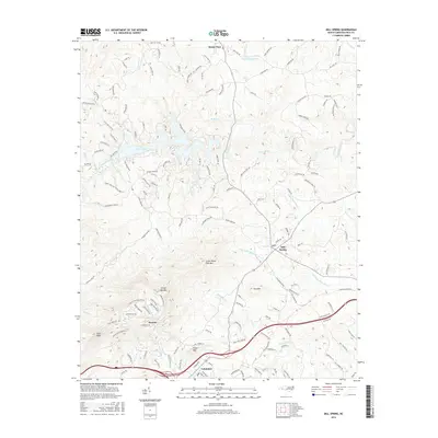
2016 Map of Mill Spring
USGS Topo · Published 2016About this map
The town of Columbus serves as a prominent anchor in this North Carolina landscape, where the foothills rise toward Tryon Peak and White Oak Mtn. This 2016 survey illustrates a region defined by its water and high relief, with the Green River feeding into Lake Adger and numerous named drainages like Britten Cr and Silver Cr carving through the terrain. The map records the distribution of settlements from the concentrated streets of Columbus to the smaller crossroads of Mill Spring, Stearns, and Sunny View.
Find a feature on this map
145 named features on this map. Tap any name to fly to it.
Don’t see what you’re looking for? This feature index may not catch every label — zoom into the map to look around manually.
Map Details
Editions of this 2016 Mill Spring Map
This is the sole edition of this map. No revisions or reprints were ever made.
Other maps of this area

1907 · Saluda
USGS Topo · 1:125,000

1935 · Batcave
USGS Topo · 1:24,000

1935 · Fishtop
USGS Topo · 1:24,000

1946 · Bat Cave
USGS Topo · 1:24,000

1946 · Cliffield Mtn
USGS Topo · 1:24,000
1947 · Bat Cave
USGS Topo · 1:24,000

1947 · Cliffield Mtn.
USGS Topo · 1:24,000

1955 · Knoxville
USGS Topo · 1:250,000

1957 · Knoxville
USGS Topo · 1:250,000

1959 · Lake Lure
USGS Topo · 1:62,500