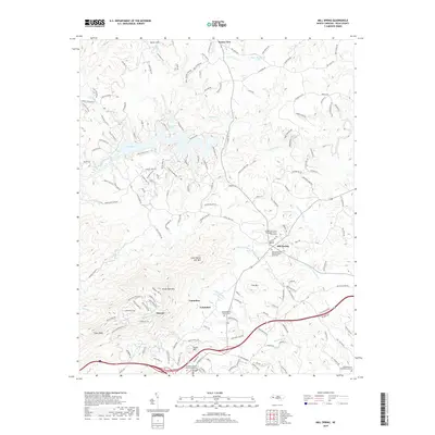
2019 Map of Mill Spring
USGS Topo · Published 2019About this map
Columbus serves as a focal point in this portion of Polk County, where the terrain shifts from the prominent heights of Tryon Peak and White Oak Mtn down toward the winding course of the Green River. The landscape is defined by several notable peaks, including Little White Oak Mtn and Foster Mtn, which overlook a network of valley settlements. This 2019 survey documents a region where community life is anchored by long-standing institutions, evidenced by the numerous burial grounds such as the Columbus Baptist Church Graveyard and Mill Spring First Baptist Church Graveyard. In the northern reach of the quadrangle, Lake Adger and the smaller Kaye Thompson Lake provide significant water features amidst the ridges. The settlement pattern follows the drainage of White Oak Cr and Little White Oak Cr, with small communities like Mill Spring, Stearns, and Sunny View connected by a dense web of local roads such as Big Level Rd and S Wilson Hill Rd.
Find a feature on this map
163 named features on this map. Tap any name to fly to it.
Don’t see what you’re looking for? This feature index may not catch every label — zoom into the map to look around manually.
Map Details
Editions of this 2019 Mill Spring Map
This is the sole edition of this map. No revisions or reprints were ever made.
Other maps of this area

1907 · Saluda
USGS Topo · 1:125,000

1935 · Batcave
USGS Topo · 1:24,000

1935 · Fishtop
USGS Topo · 1:24,000

1946 · Bat Cave
USGS Topo · 1:24,000

1946 · Cliffield Mtn
USGS Topo · 1:24,000
1947 · Bat Cave
USGS Topo · 1:24,000

1947 · Cliffield Mtn.
USGS Topo · 1:24,000

1955 · Knoxville
USGS Topo · 1:250,000

1957 · Knoxville
USGS Topo · 1:250,000

1959 · Lake Lure
USGS Topo · 1:62,500