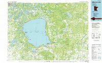
1985 Map of Mille Lacs Lake
USGS Topo · Published 1985About this map
Mille Lacs Lake dominates this central Minnesota landscape, its shoreline defined by deep bays like Malmo Bay and Wigwam Bay. By the mid-1980s, the region supported a mix of lakeside settlements and extensive protected lands. The western shore features the community of Garrison, while the southern reaches include Wahkon and Onamia, the latter situated near the headwaters of the Rum River. Public lands are prominent, including the large Mille Lacs Kathio State Park and Father Hennepin State Park, preserving the area's natural character.
Find a feature on this map
83 named features on this map. Tap any name to fly to it.
Don’t see what you’re looking for? This feature index may not catch every label — zoom into the map to look around manually.
Map Details
Editions of this 1985 Mille Lacs Lake Map
2 editions found
Other maps of this area

1912 · Deerwood
USGS Topo · 1:62,500

1913 · Cuyuna
USGS Topo · 1:62,500

1914 · Deerwood
USGS Topo · 1:62,500

1914 · Aitkin
USGS Topo · 1:62,500

1915 · Aitkin
USGS Topo · 1:62,500

1915 · Cuyuna
USGS Topo · 1:62,500

1915 · Brainerd
USGS Topo · 1:62,500

1916 · Wealthwood
USGS Topo · 1:62,500

1918 · Brainerd
USGS Topo · 1:62,500

1948 · Pierz
USGS Topo · 1:62,500