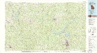
1981 Map of Milledgeville
USGS Topo · Published 1981About this map
The Oconee River and Ocmulgee River drain a diverse landscape of protected woodlands and growing towns in central Georgia during the early 1980s. This survey highlights the significance of Lake Sinclair, a large reservoir north of Milledgeville that reshaped the geography of the surrounding Oconee National Forest. The map documents the region's transportation network, including the Central of Georgia and Southern railroads which connect established settlements like Eatonton, Monticello, and Gray. Large conservation tracts like the Piedmont National Wildlife Refuge contrast with the burgeoning residential areas of Hardwick and Alcovy Shores. This detailed view of the Piedmont Plateau reveals how early river-based settlements evolved into modern regional hubs while maintaining significant forest and wildlife corridors along waterways like Murder Creek and the Towaliga River.
Find a feature on this map
97 named features on this map. Tap any name to fly to it.
Don’t see what you’re looking for? This feature index may not catch every label — zoom into the map to look around manually.
Map Details
Editions of this 1981 Milledgeville Map
2 editions found
Other maps of this area

1888 · Atlanta
USGS Topo · 1:125,000

1890 · Atlanta
USGS Topo · 1:125,000

1892 · Atlanta
USGS Topo · 1:125,000

1895 · Atlanta
USGS Topo · 1:125,000

1896 · Monroe
USGS Topo · 1:125,000

1906 · Crawfordville
USGS Topo · 1:125,000

1912 · Milledgeville
USGS Topo · 1:62,500

1916 · Irwinton
USGS Topo · 1:62,500

1920 · Irwinton
USGS Topo · 1:62,500

1951 · Yatesville
USGS Topo · 1:62,500