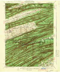
1941 Map of Millheim
USGS Topo · Published 1941About this map
Millheim and Aaronsburg anchor this 1937 survey of Central Pennsylvania, where the ridge-and-valley topography of the Bald Eagle State Forest dictates the settlement patterns. Villages like Rebersburg and Tylersville follow the longitudinal floor of the Sugar Valley, while the southern half of the map is dominated by the steep parallel ridges of Nittany Mountain and Brush Mountain. The landscape reveals a transition toward conservation and recreation, evidenced by the Voneida State Forest Park and a CCC Camp established during the New Deal era. Local history is preserved in the placement of the Joyce Kilmer Monument and the Woodward Cave, a natural landmark south of Woodward. Deep within the hollows, industrial and community remnants such as the BM Sawmill and the Hironimus Sch mark the intersections of Penn Creek and its many tributaries.
Find a feature on this map
89 named features on this map. Tap any name to fly to it.
Don’t see what you’re looking for? This feature index may not catch every label — zoom into the map to look around manually.
Map Details
Editions of this 1941 Millheim Map
3 editions found

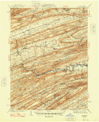
Other maps of this area

1907 · Millerstown
USGS Topo · 1:62,500

1921 · Howard
USGS Topo · 1:48,000

1921 · Williamsport
USGS Topo · 1:48,000

1921 · Lock Haven
USGS Topo · 1:62,500

1923 · Howard
USGS Topo · 1:62,500

1923 · Lock Haven
USGS Topo · 1:62,500

1923 · Williamsport
USGS Topo · 1:62,500

1924 · Centre Hall
USGS Topo · 1:62,500

1924 · Lewistown
USGS Topo · 1:62,500

1925 · Mifflintown
USGS Topo · 1:48,000