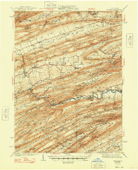
1941 Map of Millheim
USGS Topo · Published 1948About this map
Nittany Mountain and a series of parallel ridges define the landscape of this central Pennsylvania region during the late 1930s. The settlement pattern follows the narrow valleys, with Millheim and Aaronsburg serving as primary hubs along State Route No. 45. This era shows a transition in land use, as former industrial sites like the Sawmill near Ingleby give way to conservation and recreation efforts within the Bald Eagle State Forest.
Find a feature on this map
136 named features on this map. Tap any name to fly to it.
Don’t see what you’re looking for? This feature index may not catch every label — zoom into the map to look around manually.
Map Details
Editions of this 1941 Millheim Map
3 editions found

Other maps of this area

1907 · Millerstown
USGS Topo · 1:62,500

1921 · Howard
USGS Topo · 1:48,000

1921 · Williamsport
USGS Topo · 1:48,000

1921 · Lock Haven
USGS Topo · 1:62,500

1923 · Howard
USGS Topo · 1:62,500

1923 · Lock Haven
USGS Topo · 1:62,500

1923 · Williamsport
USGS Topo · 1:62,500

1924 · Centre Hall
USGS Topo · 1:62,500

1924 · Lewistown
USGS Topo · 1:62,500

1925 · Mifflintown
USGS Topo · 1:48,000