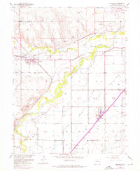
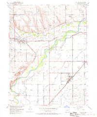
1950 Map of Milliken
USGS Topo · Published 1976About this map
Irrigated agriculture and a dense rail network define this Weld County landscape, where the Big Thompson River and Little Thompson River converge before joining the South Platte River. The map reveals a complex system of water management essential to the region's development, featuring numerous irrigation works such as the Godfrey Ditch, Mutual Ditch, and Farmers Ditch. Small agrarian settlements like Milliken and Gilcrest serve as focal points for the surrounding farmsteads, while vanished or smaller sidings like Adna, Dent, and Peekham reflect the historical importance of the Union Pacific and Great Western railroads.
Find a feature on this map
31 named features on this map. Tap any name to fly to it.
Don’t see what you’re looking for? This feature index may not catch every label — zoom into the map to look around manually.
Map Details
Editions of this 1950 Milliken Map
6 editions found
Other maps of this area

1902 · Greeley
USGS Topo · 1:125,000

1949 · Gowanda
USGS Topo · 1:24,000

1949 · Platteville
USGS Topo · 1:24,000

1950 · Greeley
USGS Topo · 1:24,000

1950 · Gowanda
USGS Topo · 1:24,000

1950 · Platteville
USGS Topo · 1:24,000

1950 · Windsor
USGS Topo · 1:24,000

1950 · Johnstown
USGS Topo · 1:24,000

1950 · Bracewell
USGS Topo · 1:24,000

1950 · Milliken
USGS Topo · 1:24,000